There are red blotches all over the Kansas map again tonight. Tornado warnings are in abundance through the center third of the state.
In Emporia, so far, just even gray clouds and a pile of humidity. But that can change quickly.
Earlier I sent a message to a high school friend from Macksville to check on his family’s welfare. From the map, it looked like the tornado must have passed right by or over his family’s Pratt County home. Terry called this evening. Yep, it was close, but his farm is mostly OK. Some relatively minor damage – 4 dead sheep, an irrigation system mangled, a missing 4-wheeler. (He’s trying to calculate the trajectory of a 4-wheeler in an F-5 tornado.)
Anyway, the good news is that Terry and his family are fine and his house is OK. But nearby, an elderly neighbor was killed in his rural home. A number of other farm homes in the Macksville area were damaged or destroyed. A Macksville Police Officer was critically injured.
For more information, check out KWCH.
And, KSN has information on damage other towns – St. John, Macksville, Trousdale, Ellinwood, Claflin. The damage in these places was much less severe than in Greensburg.
Right now, KWCH is saying a tornado is at Belpre, headed toward the Pawnee Rock area (my hometown.) And a tornado on the ground 4 miles SE of Chase in Rice County.
Here’s a story of survival in Greensburg.
18:20 – baseball-size hail in Larned. ouch!
18:28 – Osborne County in North Central Kansas was hit by a tornado this evening. Heard that the Circle Inn Restaurant got hit. Dave and I ate there in October. Nice place. And that restaurant had just been rebuilt after a fire in the recent past. Some injuries in Osborne County.
18:47 – Pawnee Rock is in the pink zone (HAIL). It’s still in a tornado warning. Hopefully, it will survive. Dundee, Heizer and Great Bend are all in the line of fire.
18:49 – Merril Teller on KWCH is reporting a tornado near Pawnee Rock. (but where near PR?) Reported by a trained weather spotter. Aimed for Great Bend, ETA 18:56.
18:50 – they are reporting that at 18:45, a tornado is on the ground 6 miles SW of Great Bend (hope my dad and step-mom are hiding!) Also a funnel cloud (in the air, not on the ground) 1 mile SW of Great Bend.
18:59 – Rotation right over Great Bend. Funnel clouds and tornadoes reported.
19:00 – Meanwhile, two areas of rotation near Greenburg, site of last night’s storm.
19:10 – KWCH said they’ve been on the air for 22 straight hours with tornado coverage.
19:13 – Barton County Sheriff said (unk time of report) that they expected tornado to clip west edge of Great Bend.
19:14 – Tornado on the ground (rope tornado) touched down in Kiowa County (SW of Haviland.)
19:17 – Funnel (or tornado?) over the center of Great Bend at 19:14. More than one funnel/tornado in GB area. Storms headed to Claflin, Holyrood. Street flooding in Hoisington. This is a complex of storms joined together. Flash flood warning for Barton County until 4 a.m.
19:25 – Barton County Sheriff reports funnel clouds were in the Great Bend area, but no reports of damage! Good news. Half-dollar sized hail. Funnel southwest of Hoisington (different storm than the GB storm).
19:30 – Tornado warnings for SE Edwards, NW Pratt, parts of Stafford County.
19:30 – Tornado on ground 4 miles NW of Claflin, moving NE at 35 mph. Headed toward Russell and Ellsworth County. Street flooding reported in Great Bend.
19:37 – The Kiowa County storm has moved NE and is now in the area of Terry’s house (friend mentioned above). ETA in Hopewell 19:43, Hopewell 19:48, Macksville 20:14.
19:46 – tornado on the ground N of Susank (in northern Barton Co.) Wilson should be receiving large hail soon. Area of rotation headed that way, ETA 20:03. Flash flooding in Russell and Lincoln Counties.
20:00 – Rain-wrapped tornado 4 miles S of Wilson, headed for Wilson in Russell County.
20:01 – rotation, tornado on the ground headed toward Macksville, Dillwyn, St. John, Radium, Seward (Stafford County). Large and potentially dangerous tornado on the ground 1 mile SE of Macksville.
20:05 – tornado on the ground just south of Wilson, moving NE. Lucas, Sylvan Grove, Wilson Lake. Rain-wrapped tornado, means you can’t see it coming. Large hail should be in Sylvan Grove in next 10 min. Flooding.
20:09 – Radium and Pawnee Rock in the path of the Stafford County tornado – large tornado on the ground. 8:35 ETA to Radium. 8:48 at PR.
20:10 – Rain-wrapped tornado about to cross I-70, 2 miles W of Wilson. Another funnel 9 miles N of Claflin.
20:16 – extensive tree damage near Hopewell (Pratt County). Roof blown off home. Roads nearly impassible due to trees – and power lines- down.
20:17 – tornado in Stafford County is half-mile wide. This tornado possibly went through Macksville – no reports yet. Storm is moving west of Hudson, headed for Radium.
20:21 – two tornadoes on ground in Stafford County. The large wedge tornado reportedly missed Macksville, but has caused significant damage to at least one residence.
20:26 – wedge tornado is still on the ground, N of St. John. Rope tornado in area also.
20:34 – two large wedge tornadoes on ground in Stafford County, 3 mi, N-NW of St. John.
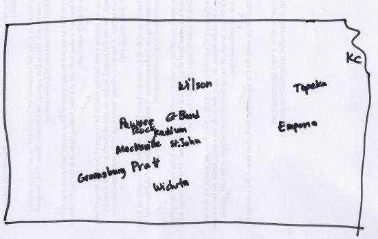
OK, Cheryl’s quick-draw map to give you non-Kansans an idea of where in the state these storms are. The center of the state is being battered.
Even after one tornado moves through, other storms form.
20:37 – Report: the tornado sirens in Barton County are not working! Another storm is headed that way.
20:46 – Brief tornado touchdown 2 miles W of tornado-battered Greenburg.
20:46 – Back to North Central Kansas – tornado warning for Lincoln County and Mitchell County (this is the Wilson tornado). Golf-ball sized hail at Sylvan Grove.
20:49 – Stafford County tornadoes closing in on Hudson. Tornado 3 mi SE of Seward.
20:51 – Another tornado warning (Doppler indicated) starting for SE Edwards/NE Kiowa. Headed for Trousdale at 21:03. Belpre 21:16, Macksville 21:24, Zook 21:27.
20:54 – Stafford County tornadoes: KDOT reports tornado crossing US 281 at K-19, 2 miles E of Seward.
20:57 -Oops, now the storms are getting close to Emporia. Thunderstorm warning in Chase County – over Cottonwood Falls and Strong City, headed toward Council Grove.
21:00 – Tornado sirens are now working again in Great Bend. Good thing – cause the tornadic stuff is headed up US 281, aiming for Great Bend and Ellinwood. Sirens going off in Great Bend and Ellinwood.
21:04 – Radar indicating possible tornado near Lincoln in Lincoln County. Mitchell County also in danger.
21:06 – Area of rotation 4 mi. S of Great Bend. Another area of rotation S of Ellinwood. Large tornado on the road 7 miles SW of Ellinwood – confirmed report. They’ve been tracking this particular cell for over two hours.
21:07 – tornado warning for Lincoln County has been cancelled. Storm weakened.
21:09 – Doppler radar shows rotation directly over Trousdale. Confirmed by law enforcement. Moving toward Macksville, ETA 21:23. (Third round of tornadoes for Macksville).
21:12 – 3 miles south of Ellinwood – tornado on the ground. KWCH storm chaser report. May pass between Great Bend and Ellinwood.
21:14 – Tornado warning for E Barton, W. Rice, S. Ellsworth. Large and destructive tornado is on the ground.
21:14 – New tornado warning. Edwards, Stafford, Pawnee County. The Trousdale tornado continues, moving N-NE at 40 mph. Belpre, Macksville, Zook, Radium, Seward in danger.
21:17 – 1 mile S of Ellinwood, KWCH Storm Team, heavy rain, lightning, hard to see tornado/funnel. Going over western edge of Ellinwood right now.
21:18 – NWS reports multi-vortex tornado and wedge tornado S of Ellinwood. Transformer blew in Ellinwood earlier and electrical fire in a business. Ellinwood appears to be without power right now.
21:20 – Area of rotation may pass just to the west of Ellinwood, but too close to call.
21:20 – Trousdale tornado – now moving north – just to west of Macksville at this time, moving to NE 45 mph. Large hail probably occuring in Belpre area.
21:23 – Eastern Morris/Eastern Chase County – 1/2 inch hail, 60 mph hour winds were in Cottonwood Falls/Strong City.
21:26 – 70-80 mph winds in Belpre. Rear-flank downdraft on back side of storm that is moving through Edwards/Pawnee County. Tornado now at Macksville.
21:27 – Storm damage reported 5 miles SE of Great Bend. House with roof damage. Dmg to outbuildings.
21:27 – Claflin, Bushton, Holyrood in line of tornadic thunderstorms. Sirens continue to sound in Great Bend and Ellinwood.
21:29 – Ellinwood – straight winds – rear flank downdraft of storm. Horizontal winds. Power poles are swaying reported by KWCH StormTeam chaser. Still have power on in Ellinwood. Straight-line winds likely to cause roof damage in Ellinwood now. 70-90 mph winds estimated. Torrential rain. Area of rotation N-NW of Ellinwood headed toward Claflin.
21:32 – Another new warning. SE Pawnee/NW Stafford (the Trousdale/Macksville storm). Dillwyn, Radium, Seward in danger.
21:33 – Thunderstorm warning SE of Meade. Quarter-size hail. Thunderstorms near Ford, Bucklin,
21:33 – Trousdale storm – SE corner of Pawnee County heading across Stafford County. “Once again you see the names we’re all familiar with,” Merril Teller said. This storm projected to reach Radium at 21:44, Seward, 21:48, Dundee 21:57, Great Bend 22:06.
21:36 – Ellinwood tornado, 6 mi NW of Silica. Has been a tornadic storm since Commanche County.
21:37 – Trousdale tornadic cell – no confirmed tornadoes, but see rotation on Doppler radar. “Taking a bead on Radium.” In next 5 minutes.
21:39 – New tornado warning for North Central Kansas – Jewell / Mitchell Counties.
21:40 – Tornado warning will probably be extended – cell holding together – near Claflin, Bushton. No confirmed tornado reports on this storm for the last 10-15 minutes. Large hail.
21:42 – KWCH StormTeam chaser Lance Ferguson- 3 mi W of St. John, says … wall cloud lowering. Very well put together. Formed a funnel. We’re waiting for the lightning to confirm that it has formed a tornado. Not enough light to see what’s going on. (Trousdale storm)
21:44 – NWS extended tornado warning for NW Rice, E Barton, Ellsworth Counties. (S-SE of Claflin 2 miles is the rotation. Headed for Bushton, Lorraine.
(I have to go to the bathroom – don’t these weathermen ever take a break?)
21:48 – Damaging straight-line winds Meade and Clark Counties in SW Kansas. 80 mph.
21:49 – Dodge City vicinity – thunderstorms
21:53 – 4 miles SE of Bushton, EMS reports of tornado on the ground. Could possibly be two tornadoes in this area. Wind gusts 80 mph.
21:53 – rotation in storm 10 miles SE of Pawnee Rock, 35 mph. New tornado warning for W Barton County – Pawnee Rock, Great Bend in danger. Tornado warning until 22:30.
21:59 – Area of rotation moving in on Holyrood. Guessing they’re having 80, 90, 100 mph winds.
22:00 – KWCH meterologist Merril Teller, “As we continue our continuous coverage… ” turning it over to Roger Cornish for the 10:00 news. Curfew in effect for Greensburg – began at 8 p.m. Anyone seen out in Greensburg will be arrested.
22:02 – tornado confirmed US 281 at Barton/Stafford County line. Getting very, very close to Great Bend ETA 22:05.
22:03 – 4 mi N of Bushton, tornado on the ground – in Ellsworth County. Also another tornado spotted near Holyrood. Headed for Ellsworth. Not seeing any weakening with this storm – been tracking for hours.
22:05 – tornado on ground just S of Great Bend. May go east of Great Bend.
22:06 – 1.5 inch hail in Clark County. Thunderstorm warning.
22:06 – Ellsworth County – confirmed tornado on the ground near Holyrood, following K-156 heading toward Ellsworth, ETA 22:25.
22:08 – Bushton, winds 70-80 mph.
22:09 – S-SE of Great Bend moving N-NE. Very close to Great Bend. ETA GB 20:12, Claflin 20:34.
22:10 – Golf ball size hail Kanopolis area.
22:12 – tornado information on hold while Roger Cornish gives the “news.” … Hey, what about Ellinwood, what about Great Bend, what about Ellsworth, Holyrood? There are still tornadoes hanging in the air – and they’re talking about what happened in Greensburg today. OK, back to weather.
22:17 – Tornado sirens are not going off in Great Bend, though they should be.
22:18 – Some damage to homes reported in Odin in Barton County.
22:18 – storm 5 miles SW of Ellsworth, Kanopolis. Moving up K-156.
22:20 – strong winds in Bushton, Geneseo areas 70 mph
22:20 – Great Bend storm – some rotation indicated NE of Great Bend. Heavy rainfall. Rain-wrapped storm. No further reports of tornadoes on ground – but storm still shows signs of rotation.
22:22 – new storms developing in Ford County. T-storm warning, but nothing of a severe nature yet.
22:22 – hail over Ellsworth, possibly larger than 1 inch.
22:24 – Barton, Lincoln, Russell, Ellsworth, Pawnee, Stafford Counties all have flash flood warnings.
22:28 – Meanwhile, in Fall River, the deck of a house collapsed today. One man from Wichita is dead. It was a new house, a housewarming, most of the guests at the party were from Wichita.
22:32 – Tornadic storm aiming for Claflin, Odin…
22:33 – Bushton – reports of power poles down, structural damage. This storm now in Ellsworth Co. Rotation N of Ellsworth.
22:35 – Strong thunderstorms – a line from Meade, through Kinsley to Larned. Hail and winds in excess of 60 mph.
22:37 – Barton County Sheriff report 1 foot of water across US 56 at PAWNEE ROCK.
22:37 – Now a new line of thunderstorms developing in NW Kansas, a vertical line from Norton down to Lane. Severed T-storm warning in Smith County. Quarter-size hail potential.
22:39 – Area of rotation tightening up in N Ellsworth County. Near Kanopolis, about to cross I-70, no reports of tornado, but Doppler radar indicates possibility.
22:39 – Area of rotation NW of Claflin. No confirmation of funnels – but it’s dark out there.
22:41 – 3 inches of rain in Hoisington tonight.
22:42 – golf ball sized hail likely in northern Ellsworth county. N. of Kanopolis, N of Ellsworth.
22:43 – no confirmed tornadoes for past 30 minutes.
22:43 – large hail likely Kinsley to Larned area.
22:53 – Yesterday’s storm knocked down power poles in the Bushton area. Those were replaced today. Knocked down again tonight.
Enough. Four hours spent following a wild night in Kansas. It’s not over in Kansas yet, but I’m shutting her down for the evening.
As Edward R. Murrow would say, “Good night and good luck.”
Cheryl, your blog on this is gripping, urgent.
Wild stuff out there in Central Kansas tonight, huh?
Scary stuff. I keep coming back to see what you’ve written. I’ve been watching tv too, but somehow reading it feels more urgent. I will be glad when this week is over.
On channel 13, they reported large hail south of Topeka.–and it’s pouring heavy rain.
A new tornado warning–Blue Rapids, Waterville–over to Marysville. This is just terrible.